Sunday 17 April 2016

Part 8: National Park and Route 37

Part 8

National Park by Morning

Route 37

Route 37 is a tiny route in central Johto. It connects route 36 to Ecruteak with the closest other city being Violet City. It is only 64x64 blocks wide and is about as basic as a route gets. 

The process is the same process as usual. Create borders and fill them in with trees.

And there it is all complete.

National Park

The National Park is one of the largest landmarks in Johto. Nothing special happens here except the Bug Catching contests in the GBC and DS games. 

A characteristic of the park is its huge Pokeball defined with tall grass in the upper and lower halves with a large fountain in the centre.

The park is a little non-standard with its size. It pushes about half a chunk too far north of where I'd like it to be. So I guess Route 38 which is directly north of the park will be modified to fit.

Another thing that is a little non-standard. The gates don't quite line up.

Simple solution. Block off one entrance/exit on each station and build a tunnel to connect them.

Another thing that needed to be changed was the picnic area at the southern end. It only had to be mirrored otherwise the building to access the National Park from Route 35 would have to be widened to twice its width.

Trees go in now. Same process as always.

But not before adding some scenery.

Ok, now the trees. Now it is finished.

If you are wondering if I'd forgotten about the Pokeathlon Dome, I haven't, It just wont fit otherwise it will conflict with Olivine City when it's build. But if it does fit, it gets built.

Finished Product

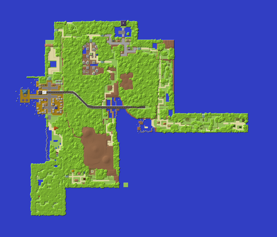
Most of the region in its current state. 

The National Park.

The building to access the park from the south.

Picnic area.

Pokeball Park.

The fountain behind the grass.

The north eastern quadrant of the park.

Route 37

Access point to route 37 from route 36.

Lone tree.


Progress so far.


Stay tuned and subscribe.
PS: Check this project out on Planet Minecraft.
http://www.planetminecraft.com/project/pokmon-johto-and-kanto-regions/

And sample the progress so far by downloading the world here:
https://www.dropbox.com/s/u4lbsvbdxulldfe/JohtoKantoSnap8.zip?dl=0

If you have any tips for improvement please don't hesitate to share. It would be greatly appreciated. Next: Part 9 features Ecruteak City.
After That: Part 10 features Mahogany Town and Route 43.
And After That: Part 11 features Route 32 and Mt Mortar
16% Complete.

Sunday 10 April 2016

Part 7: Route 34 and Ilex Forest

Part 7
Ilex Forest Shrine

The missing link between Azalea Town and Goldenrod City. Ilex Forest and Route 34

Route 34

Route 34 is a medium length route joining Goldenrod City to Ilex forest. It is a coastal route with a small area to the south accessible only by water. 

And immediately there is a problem. See the gate, well, Ilex Forest is aligned there at its north eastern corner. So it will intersect the portion of Route 34 down south.

We'll deal with that later. But here is the Daycare Centre.

It is an L-shaped building that looks like a barn house. A small picket fence completes the daycare centre.

Ilex Forest

Ilex Forest is one of the more famous places in Johto. It is a mystical forest shrouded by trees. 

I laid the foundations off the map so I could find a place to slot it in closer to Azalea Town and Route 34.

The Shrine. The only point of interest in the forest. As many people know it is where any player playing a Japanese version of Pokemon Crystal can catch a Celebi provided they have a GS Ball.

To join the entrances and exits to Ilex Forest long walkways had to go in. But it makes the forest feel remote and secluded even though it is no more than 10 blocks from Azalea Town.

Because of Ilex Forest's mystical nature I thought a change of vegetation was in order.

Dark Oak trees have expansive leaf coverage and huge, chunky trunks.

But they must be planted in a 2x2 configuration. But whatever, I think the result will be worth it.

And it was worth it. Much of the area is covered by leaves which lowers the light level and adds to the spookiness.


This is the effect the roofed forest has on lighting.


Near both the gates there is a blend of both dark oak and normal oak trees.

Finished Product

Route 34 looking towards Goldenrod City. 

The Daycare Centre

Goldenrod City.

The southern, hidden section with a massive puddle.

Corridor for the hidden section.

The walkway into Ilex Forest.

Looking up at the sky.

South eastern quadrant of the forest.

The Shrine.

The forest lake.

Somewhere in the forest.

An open area up north.

The northern exit from the forest.

The northern walkway.

Leaving Ilex Forest gate onto Route 34

Progress so far


Stay tuned and subscribe.
PS: Check this project out on Planet Minecraft.
http://www.planetminecraft.com/project/pokmon-johto-and-kanto-regions/

And sample the progress so far by downloading the world here:
https://www.dropbox.com/s/w4rkhcnp59lkg8d/JohtoKantoSnap7.zip?dl=0

If you have any tips for improvement please don't hesitate to share. It would be greatly appreciated. Next: Part 8 features the National Park and Route 37.
After That: Part 9 features Ecruteak City.
And After That: Part 10 features Mahogany Town and Route 43
14% Complete.