I've decided to discontinue the blog. It is the bottleneck in the project. I just don't want to write up individual screenshots any longer.
The project is still going, however. Although progress is slow it is getting there. All progress can be viewed on Planet Minecraft.
http://www.planetminecraft.com/project/pokmon-johto-and-kanto-regions/
Thanks for your support.
Tuesday 21 March 2017
Tuesday 14 February 2017
Part 24: Route 26 and 27
Part 24
How long has it been? 2 months? I had this planned for release since October 2016 but just didn't get around to it until now.
The route is a mix of ocean, foothills and mountains.

The route is held together with two bridges, staircases and Tohjo Falls to make the route traversable.


Tohjo Falls is a feature on the route that must be navigated to get to the other side. It was built away from the route as that is how caves are now produced. It is a normal cave with coarse dirt walls, floor and ceiling.

Deep inside Tohjo Falls is a broken radio. No idea why.

Tohjo Falls is quite tall as it need to accommodate a waterfall. This will become quite annoying later when the time comes to smooth the exterior to blend into the overworld without comprimising the interior of Tohjo falls too much.

The front wall was quite plain looking so some extra coarse dirt was brushed on to make it more interesting.
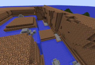
With a roof attached you get the mysterious dark glow that caves really require.


The route goes up the side of a mountain. It was constructed in layers to accurately reproduce the route.


Details such as the grass, trees and other vegetation get added as well as buildings.

Once the trees are grown the route can be declared complete.


Western end of route 27.

Tohjo Falls.

Mid-section of route 27.


Section of route 27 built into the hillside.

Eastern end of route 27 and the start of route 26.

Grassy area on route 36


Northern end of route 26.

Progress so far.

Stay tuned and subscribe.
PS: Check this project out on Planet Minecraft.
http://www.planetminecraft.com/project/pokmon-johto-and-kanto-regions/
And sample the progress so far by downloading the world here:
https://www.dropbox.com/s/pkett4y7ip8lopu/JohtoKantoSnap24.zip?dl=0
If you have any tips for improvement please don't hesitate to share. It would be greatly appreciated. Next: Victory Road and Indigo Plateau
After That: Route 28 and 22
And After That: Viridian City
49% Complete.
How long has it been? 2 months? I had this planned for release since October 2016 but just didn't get around to it until now.
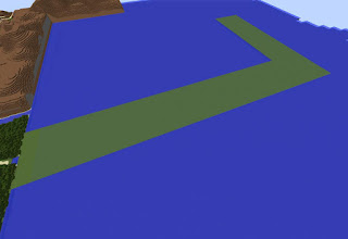
Route 27
Route 27 is the first step into Kanto. It is a long east-west route set on the side of a cliff.

The route is a mix of ocean, foothills and mountains.

The route is held together with two bridges, staircases and Tohjo Falls to make the route traversable.


Tohjo Falls is a feature on the route that must be navigated to get to the other side. It was built away from the route as that is how caves are now produced. It is a normal cave with coarse dirt walls, floor and ceiling.

Deep inside Tohjo Falls is a broken radio. No idea why.

Tohjo Falls is quite tall as it need to accommodate a waterfall. This will become quite annoying later when the time comes to smooth the exterior to blend into the overworld without comprimising the interior of Tohjo falls too much.

The front wall was quite plain looking so some extra coarse dirt was brushed on to make it more interesting.

With a roof attached you get the mysterious dark glow that caves really require.

Route 26
This route is a north-south route. At the southern end is the route 26/27 intersection and at the northern end is the soon to be constructed Pokemon League reception gate.
The route goes up the side of a mountain. It was constructed in layers to accurately reproduce the route.


Details such as the grass, trees and other vegetation get added as well as buildings.

Once the trees are grown the route can be declared complete.

Finished Product
Leaving New Bark Town looking east.

Western end of route 27.

Tohjo Falls.

Mid-section of route 27.


Section of route 27 built into the hillside.

Eastern end of route 27 and the start of route 26.

Grassy area on route 36


Northern end of route 26.

Progress so far.

Stay tuned and subscribe.
PS: Check this project out on Planet Minecraft.
http://www.planetminecraft.com/project/pokmon-johto-and-kanto-regions/
And sample the progress so far by downloading the world here:
https://www.dropbox.com/s/pkett4y7ip8lopu/JohtoKantoSnap24.zip?dl=0
If you have any tips for improvement please don't hesitate to share. It would be greatly appreciated. Next: Victory Road and Indigo Plateau
After That: Route 28 and 22
And After That: Viridian City
49% Complete.
Sunday 18 December 2016
Part 23: Terrain fill in and finishing touches.
Part 23
Apologies for the late update. Been extremely busy lately.
Johto is now finished so it is time to fill in the surrounding terrain.
Starting in the west the method was place chunks of terrain around the built up areas of the map.

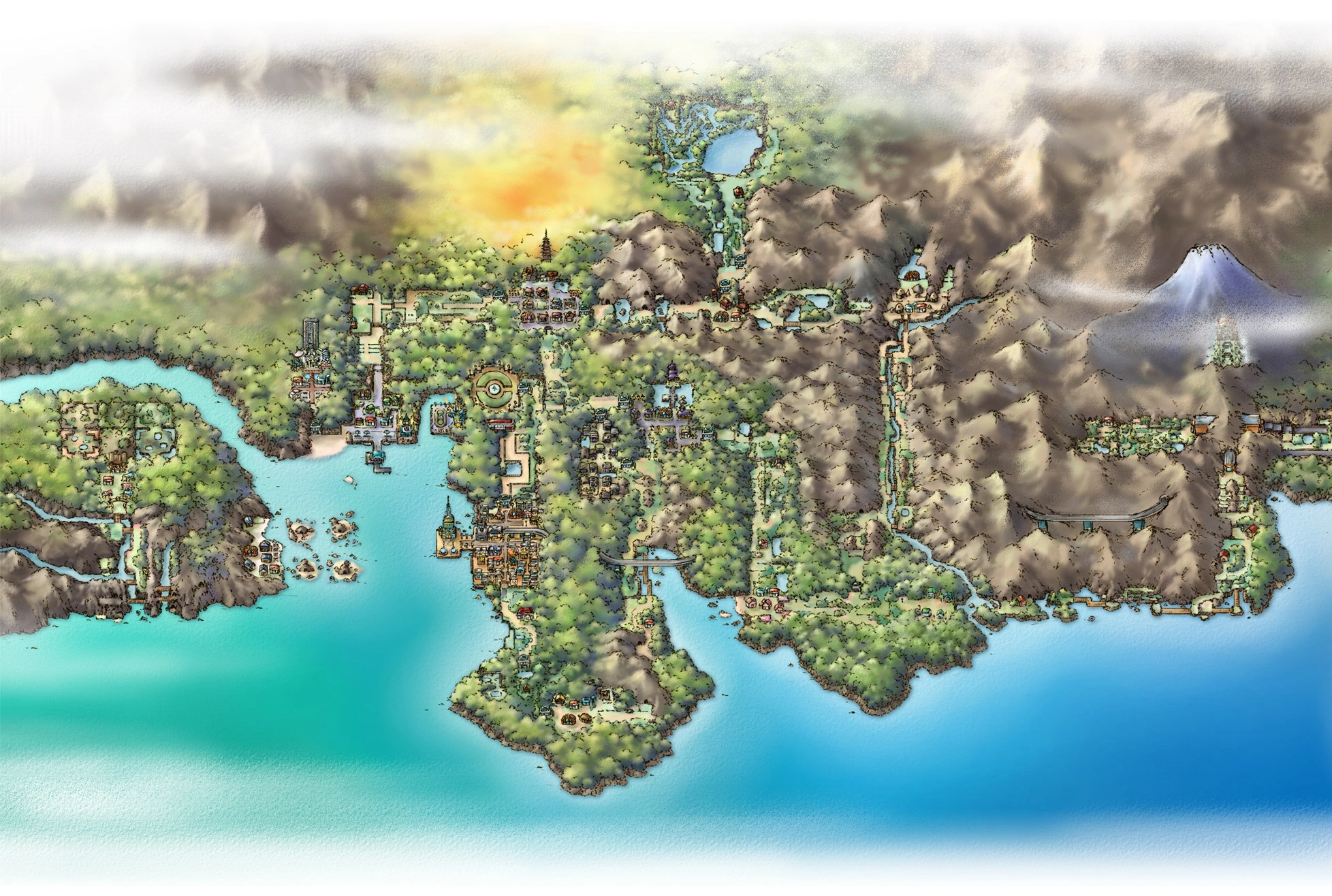
This image was used to form the mountains, river and lakes in Johto.

The chunks of terrain were smoothed out for a more natural look.

Moving south to Azalea town and Ilex forest there is a large expanse of land. It was completely flat which made it easy to complete.

A mix of Oak and Dark Oak trees were planted to blend Ilex forest into the surrounding landscape.

Moving back west to the Safari Zone where the mountains were formed.

Tree planting and growing is a time-consuming process. Until I find a way to grow trees instantly they will be growing naturally.

Heading East it is much the same process as before. Chunks of land that are then smoothed out.

In the northeast quadrant of Johto, there is a mix of mountains and plateaus. More on this area later.

Moving back south again it's just tree growing.

Moving back north (these screenshots are so out of order) near the Lake of Rage. Just more tree growing.

Completed landscape. I couldn't be bothered to take more progress screenshots as they were mostly going to be of the same thing.

The Safari Zone on the left and the Battle Frontier on the right.

Looking in the other direction.

Azalea Town and Ilex Forest peninsula.

New bark Town and Cherrygrove City

Stay tuned and subscribe.
PS: Check this project out on Planet Minecraft.
http://www.planetminecraft.com/project/pokmon-johto-and-kanto-regions/
And sample the progress so far by downloading the world here:
https://www.dropbox.com/s/jbppia489cn6ju7/JohtoKantoSnap23.zip?dl=0
If you have any tips for improvement please don't hesitate to share. It would be greatly appreciated. Next: Route 26 and 27
After That: Victory Road and Indigo Plateau
And After That: Route 28 and 22
47% Complete.
Johto is now finished so it is time to fill in the surrounding terrain.
Starting in the west the method was place chunks of terrain around the built up areas of the map.


Moving south to Azalea town and Ilex forest there is a large expanse of land. It was completely flat which made it easy to complete.


FINISHED PRODUCT
View looking west from Bell tower.


New bark Town and Cherrygrove City

Stay tuned and subscribe.
PS: Check this project out on Planet Minecraft.
http://www.planetminecraft.com/project/pokmon-johto-and-kanto-regions/
And sample the progress so far by downloading the world here:
https://www.dropbox.com/s/jbppia489cn6ju7/JohtoKantoSnap23.zip?dl=0
If you have any tips for improvement please don't hesitate to share. It would be greatly appreciated. Next: Route 26 and 27
After That: Victory Road and Indigo Plateau
And After That: Route 28 and 22
47% Complete.
Sunday 13 November 2016
Part 22: Safari Zone
Part 22
Part 22 is the Safari Zone. Exclusive to the Gen IV games it is set in far west Johto. It is place in the games where you can catch 'rare and exclusive' Pokemon.

The Safari Zone in the DS games can have up to six different areas at any one time. But because this isn't the DS game all 12 zones are here.

First up is the Savannah. Open spaces with small patches of grass shaded by acacia trees.

Next to the Savannah is the 'Peak' area. It is a rocky peak made from red sandstone with granite pathways.

And next to that is the Mountain area. Dense trees hide the grassy patches that are set within.

And there is the first three.

Next is the 'Plains' area. It is quite plain hahahaha with ample grassy patches and oak trees here and there.
Next to that is the Marshland. Similar to a swamp there are pools of stagnant water with damp oak trees surrounding them.

North of that is the desert. Very similar to the Savannah area. Acacia trees have been substituted for oak and there is less grass.

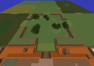
Next door is the Meadow. A wide open space with fresh ponds, flowers and tall grass.

And that is the third row complete. The area at the bottom of the screenshot is the Wasteland. I jost forgot to take a screenshot of it.

Well, that's nine of them done.

The last three we'll go over quickly. On the left is rocky beach, in the centre is the Forest and on the right is the Swampland.

The entrance to the Safari zone. There is a small town at the entrance. When I say town I mean more like a market. In the DS games you just buy stuff you don't need here.

I forgot to mention the Safari Zone was built in a separate world file. I had no idea how big it would get or how to properly place it.

The entrance. Modified slightly to accommodate the interior.


Safari Zone town.

The view from the Safari Zone.

And here it is. Johto is complete, almost.

Finished Product.

Safari Zone Town Centre.

Mountain Zone

Peak

Savannah

Wasteland

Plains

Marshland

Desert

Meadow

Wetland

Swampland

Forest

Rocky Beach

Where it all is in relation to the rest of Johto

Progress so far

Stay tuned and subscribe.
PS: Check this project out on Planet Minecraft.
http://www.planetminecraft.com/project/pokmon-johto-and-kanto-regions/
And sample the progress so far by downloading the world here:
https://www.dropbox.com/s/faphmxaylpkzhzv/JohtoKantoSnap22.zip?dl=0
If you have any tips for improvement please don't hesitate to share. It would be greatly appreciated. Next: Finishing touches for Johto
After That: Route 26 and 27
And After That: Victory Road and Indigo Plateau
45% Complete.
Part 22 is the Safari Zone. Exclusive to the Gen IV games it is set in far west Johto. It is place in the games where you can catch 'rare and exclusive' Pokemon.

The Safari Zone in the DS games can have up to six different areas at any one time. But because this isn't the DS game all 12 zones are here.

First up is the Savannah. Open spaces with small patches of grass shaded by acacia trees.

Next to the Savannah is the 'Peak' area. It is a rocky peak made from red sandstone with granite pathways.

And next to that is the Mountain area. Dense trees hide the grassy patches that are set within.

And there is the first three.

Next is the 'Plains' area. It is quite plain hahahaha with ample grassy patches and oak trees here and there.

Next to that is the Marshland. Similar to a swamp there are pools of stagnant water with damp oak trees surrounding them.

North of that is the desert. Very similar to the Savannah area. Acacia trees have been substituted for oak and there is less grass.

Next door is the Meadow. A wide open space with fresh ponds, flowers and tall grass.

And that is the third row complete. The area at the bottom of the screenshot is the Wasteland. I jost forgot to take a screenshot of it.

Well, that's nine of them done.

The last three we'll go over quickly. On the left is rocky beach, in the centre is the Forest and on the right is the Swampland.

The entrance to the Safari zone. There is a small town at the entrance. When I say town I mean more like a market. In the DS games you just buy stuff you don't need here.

I forgot to mention the Safari Zone was built in a separate world file. I had no idea how big it would get or how to properly place it.


Safari Zone town.

The view from the Safari Zone.

And here it is. Johto is complete, almost.

Finished Product.

Safari Zone Town Centre.

Mountain Zone

Peak

Savannah

Wasteland

Plains

Marshland

Desert

Meadow

Wetland

Swampland

Forest

Rocky Beach

Where it all is in relation to the rest of Johto

Progress so far

Stay tuned and subscribe.
PS: Check this project out on Planet Minecraft.
http://www.planetminecraft.com/project/pokmon-johto-and-kanto-regions/
And sample the progress so far by downloading the world here:
https://www.dropbox.com/s/faphmxaylpkzhzv/JohtoKantoSnap22.zip?dl=0
If you have any tips for improvement please don't hesitate to share. It would be greatly appreciated. Next: Finishing touches for Johto
After That: Route 26 and 27
And After That: Victory Road and Indigo Plateau
45% Complete.
Subscribe to:
Posts (Atom)